
 Izdanje Srbija
 Serbische Ausgabe
 Izdanje BiH
 Izdanje Crna Gora


 News
News


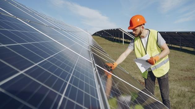
MapSoft Preparing Cadaster of Solar Potential
 Tuesday, 16.11.2021.
15:20
Tuesday, 16.11.2021.
15:20

These projects aim to calculate the solar potential of the roofs of each facility and the development of web portals through which the calculated data are shown to all interested citizens in a very simple way.
By combining their own capacities from the domain of collecting spatial data and software development, the geomatics company MapSoft from Belgrade offers, to towns and municipalities, a solution which uses the collection of spatial data through the LiDAR method (laser scanning of high density and accuracy), the calculation of the solar potential and the display of results on the MapSoft Geoportal to enable each facility owner to view, at a single click, the potential of the use of solar energy, on a monthly or a yearly level, and therefore more easily make a conclusion on the feasibility of the building in question for the installation of solar panels.
One such project has been successfully realized in Vranje, and the results can be seen at this link: https://www.gisvranje.org.rs/#/viewer/openlayers/210
Depending on the position of the Sun, the season of the year, the geometry and the nature of its surface, each roof has its own solar potential, that is, the potential for the production of energy. As the position of the Sun throughout the year is known, and the annual number of sunlit days a matter of the already determined statistics, the necessary step in calculating the solar potential is to determine the geometry of the roof structures with as much precision as possible.
The method of laser scanning from air (LiDAR) has become the dominant method for determining the geometry of roof structures. It allows the getting of very precise data in a short amount of time, based on which 3D models of the facility can be made, which allows for the optimal defining of the orientation, the angle, the usable area of the roof, as well as whether and to what extent the roof is obstructed by the neighboring structures.
Based on the collected spatial data, the IT sector of MapSoft calculates the solar potential and creates an internet portal that the citizens can access through a publicly available web address.
Na┼Ī izbor

Most Important News
06.04.2024. | Agriculture
Preconditions for Placement of Fresh Blueberries and Dried Plums in Chinese Market Secured

16.04.2024. | News
Jovan Ciric, Leasing Director Retail MPC Properties ŌĆō MPC Echo symbolizes our desire for good ideas and innovative endeavors to spread freely and bring about positive changes

16.04.2024. | News
10.04.2024. | Finance, IT, Telecommunications, Tourism, Sports, Culture
Creative Industry ŌĆō What This Serbian Economy Sector Worth EUR 2 Billion Encompasses
10.04.2024. | Finance, IT, Telecommunications, Tourism, Sports, Culture
18.04.2024. | Industry, Finance
Here come the new hunters for Serbian gold ŌĆō Australian Strickland Metals buys mining project on mountain Rogozna

18.04.2024. | Industry, Finance
16.04.2024. | News
Economy Fair in Mostar opens ŌĆō 26 companies from Serbia exhibiting
16.04.2024. | News
18.04.2024. | Transport
Jovanovic: Purchase of Siemens trams produced in Kragujevac for GSP Beograd should be considered
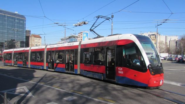
18.04.2024. | Transport