
 Izdanje Srbija
 Serbische Ausgabe
 Izdanje BiH
 Izdanje Crna Gora


 News
News


Info on locations, equipment and infrastructure at a click – Ministry of Construction and RGA planning preparation of investment maps of Serbia
 Wednesday, 18.07.2018.
14:54
Wednesday, 18.07.2018.
14:54
– A successful implementation of this project requires cooperation with local self-governments, and the most important thing is that there's a desire to realize and establish a unified model. By getting involved in this project, The Republic Geodetic Authority – The Center for Geospatial Data Management, continues its cooperation with the Ministry of Construction, Transport and Infrastructure, as this activity has been recognized as very important for the arrival of new investments. However, we still do not have precise information about the further development of this project – Nemanja Paunic of the RGA says in his interview with eKapija.
RGA experts presented their initiative for the preparation of investment maps at the Summer School of Urban Planning, organized by the Serbian Society of Urban Planners and the RGA in early June in the ethno-village of Stanisici, near Bijeljina, B&H.
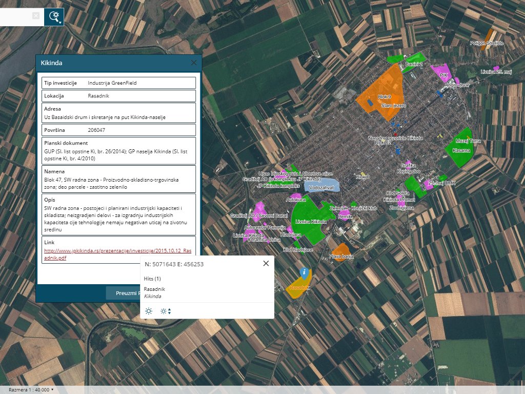
– The idea of preparing investment maps has been there for a long time, but we only realized the potential of such information in October 2017, when the Kikinda town administration adopted its study of investment locations, looking to publish them. The topic was published on our portal and recognized as a topic of national importance, especially combined with other data sets we have. Their model and their approach were very good – Paunic emphasizes and adds that, after the information was published, the Ministry of Construction mentioned that it had such data for the entire territory of Serbia.
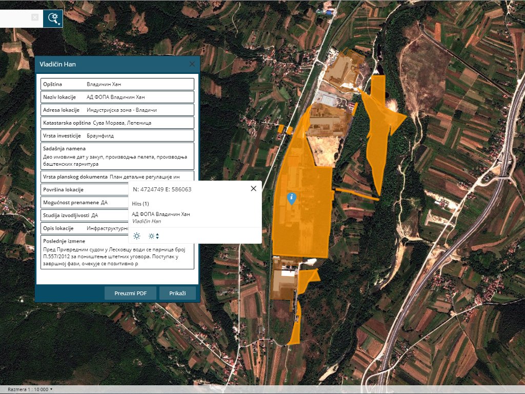
The ministry soon sent the data set for Vladicin Han to the Center for Geospatial Data Management. During the testing of the model within the pilot project, 14 of the 18 locations could be published, whereas only 69 of the said 90 parcels were located in the territory of Vladicin Han.
– The initiative of the ministry and local self-governments is excellent, and the implementation and the standardization of the model were a new challenge. Furthermore, the establishment of the mechanism for a relatively easy and inexpensive updating of the register is a special challenge, for which we've also provided a solution through the Digital Platform of the National Infrastructure of Geospatial Data. This was the topic of our presentation at the Summer School of Urban Planning in Stanisici. We took the examples of Vladicin Han and Kikinda, saw what its advantages are and what its potential flaws were, combined all those attributes and came up with the proposition for the final model of standardization, which we, in fact, tested here for the first time – explains Milena Ivanovic of the RGA, who also took part in the preparation of the investment map project.
– In developing the model of investment maps, various issues occur concerning the planning documentation, infrastructure, property-legal relations... The Center for Geospatial Data Management tries to provide all the information that citizens, state institutions and investors need through constant activities, such as the gathering of data of national importance. What we implemented in the model during the testing are the current and the planned purposes of areas, additional descriptions of the infrastructure and several other segments we believed were necessary. This way, we can offer investors that which fits into the plan for a certain area, when it comes to the purpose, the size, the infrastructure... – Ivanovic says and adds that the said information is that much more important when combined with data sets such as the data on the power network, the hydrography, the traffic routes, the digital ground model, local data sets or temporary external data sets, such as flood and landslide hazard services and similar sets.
– The Digital Platform of the National Infrastructure of Geospatial Data is precisely the tool that offers all the said features, which makes future decisions easier.
Nemanja Paunic points out that the point of investment maps is to show to the investor “quickly, through a short presentation, what you are offering, in line with their expectations”.
– This is the essence of the Digital Platform. You don't need to open a planning document and it doesn't take 20 days to prepare a presentation which would show to the potential investor that, say, there are two parcels you can offer them. This is a way to show them very quickly what you're offering and present all the options available, so that the investor would decide what suits their plans the best – Paunovic explains and emphasizes that the RGA has a very good cooperation with the Ministry of Construction.
Urban renewal
When asked what investment maps are supposed to look like, eKapija's interviewees point out that the three location types – greenfield, brownfield and grayfield – have been defined by the Ministry of Construction, and that they've tried to contribute to the project by standardizing the model.
– Brownfield and grayfield locations should be revitalized through the process of urban renewal. Our country has gone through a period of transition and the closing of companies, and these locations are therefore devastated spaces, mostly in urban areas, which means that most of the locations themselves are attractive. The idea is to enable new activities, planned in line with the currently valid documents, in those places. Of course, we also need to clarify to investors what the advantages of these locations are and why they should choose them – Milena Ivanovic says.
Marko Andrejic
Most Important News
06.04.2024. | Agriculture
Preconditions for Placement of Fresh Blueberries and Dried Plums in Chinese Market Secured

16.04.2024. | News
Jovan Ciric, Leasing Director Retail MPC Properties – MPC Echo symbolizes our desire for good ideas and innovative endeavors to spread freely and bring about positive changes

16.04.2024. | News
10.04.2024. | Finance, IT, Telecommunications, Tourism, Sports, Culture
Creative Industry – What This Serbian Economy Sector Worth EUR 2 Billion Encompasses

10.04.2024. | Finance, IT, Telecommunications, Tourism, Sports, Culture
25.04.2024. | Construction, Tourism, Sports, Culture
Zlatibor to get recreation lake in “Krst” location – Tender for preparation of documentation for construction of Miladin Pecinar dam opened

25.04.2024. | Construction, Tourism, Sports, Culture
16.04.2024. | News
Economy Fair in Mostar opens – 26 companies from Serbia exhibiting

16.04.2024. | News
24.04.2024. | Construction, Tourism, Sports, Culture
The Nis multifunctional cultural center with 2,000 spaces to be built in another location after all – Contest for preliminary design opened

24.04.2024. | Construction, Tourism, Sports, Culture